US-3424 Ice Age Floods National Geologic Trail
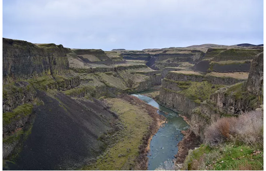
Date: 2025-01-13At the end of the last Ice Age, 18,000 to 15,000 years ago, an ice dam in northern Idaho created Glacial Lake Missoula stretching 3,000 square miles around Missoula, Montana. The dam burst and released flood waters across Washington, down the Columbia River into Oregon before reaching the Pacific Ocean. The Ice Age Floods forever changed the lives and landscape of the Pacific Northwest.
The story of the Ice Age Floods took nearly 50 years to piece together. During the 1920s–40s geologists debated the origin of eastern Washington’s Channeled Scabland where eroded volcanic basalt surrounds braided channels and coulees. Most geologists believed that the Channeled Scabland was made by slow erosion by glaciers and streams. Geologic evidence that didn’t fit with this idea led geologist J Harlen Bretz to hypothesize that the Channeled Scabland was formed by cataclysmic floods. Initially ridiculed, Bretz’s hypothesis was validated when new technologies like satellite photography provided supporting evidence. By the 1970s it was universally accepted that the scoured landscape of the northwestern United States was the result of the Ice Age Floods.
https://www.nps.gov/iafl/learn/index.htm
My Hunter Log
17:49:00 2024-12-10 WA0WWW 599 599 WA 14.043 20m CW US-3252
Comments
I welcome your comments. You do NOT need to sign in to leave a comment. If you create an account and sign in, my comment system will notify you of replies to your comment. Thanks for stopping by.--Duane McGuire